OverviewPot Map Sample

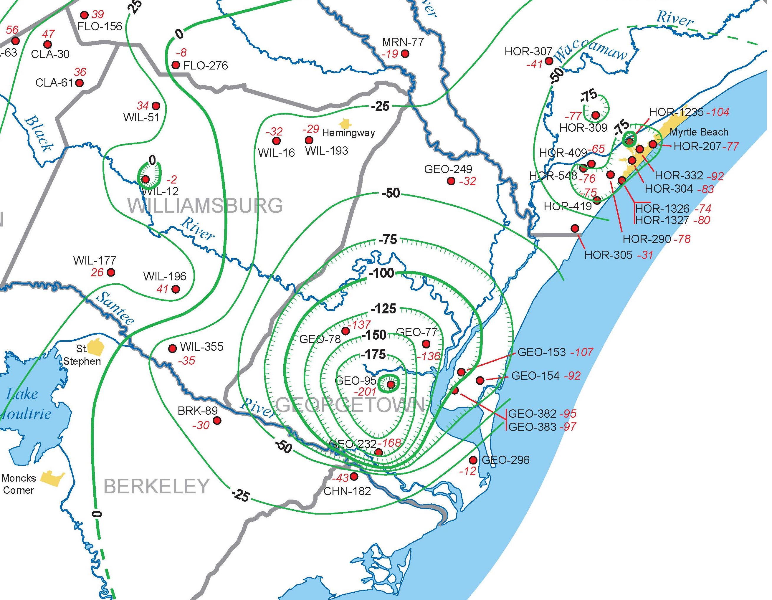
The potentiometric surface of an aquifer is defined by the elevations at which water stands in tightly cased wells completed in the aquifer. Since the 1980s, the Hydrology Section, in collaboration with the U.S. Geological Survey, SCDES, and the U.S. Department of Energy at the Savannah River Site, has prepared numerous potentiometric maps of the major Coastal Plain aquifers in order to assess changes in groundwater storage, determine regional ground-water flow directions and hydraulic gradients, calibrate groundwater models, and identify areas experiencing excessive groundwater pumping.

Water-level data used to construct these maps are collected from hundreds of wells, including numerous monitoring wells and a variety of public-supply, industrial, agricultural, and domestic wells. Typically, the potentiometric surface of one of three major Coastal Plain aquifers is mapped each year, in November and December.

For more information about the Hydrology Section’s potentiometric mapping program, contact Andrew Wachob at andy.wachob@des.sc.gov or by phone at (803)898-0324.

Potentiometric Maps

SCDNR Report 61: Potentiometric Surface Maps of the Upper and Middle Floridan and Gordon Aquifers in South Carolina, November-December 2018

SCDNR Report 60: Potentiometric Surface Maps of the South Carolina Coastal Plain, November-December 2016

SCDNR Report 56: Potentiometric Surface of the Floridan and Tertiary Sand Aquifers in South Carolina, November 2013

SCDNR Report 53: Potentiometric Surface of the Floridan and Tertiary Sand Aquifers in South Carolina, November 2010

SCDNR Report 48: Potentiometric Surface of the Floridan Aquifer and Tertiary Sand Aquifer in South Carolina, November 2004

SCDNR Report 23: Potentiometric Map of the Floridan and Tertiary Sand Aquifer in South Carolina, 1998

SCDNR Open-File Report 6: Water-level Measurements used in the Construction of the 1998 Potentiometric Map for the Floridan Aquifer and Tertiary Sand Aquifer in South Carolina

SCWRC Open-File Report 43: Water-level Measurements and Potentiometric Maps for 1991-1993 Beaufort, Colleton, Hampton, and Jasper Counties, South Carolina, with Selected Hydrographs for 1975-1993

SCWRC Open-File Report 38: Potentiometric Surface of the Upper Floridan Aquifer, Beaufort Hampton, and Jasper Counties, South Carolina, March and July 1990

SCWRC Report 157: Potentiometric Surface of the Floridan Aquifer in South Carolina, July 1986

SCWRC Open-File Report 14: Water Level Conditions in the Upper Permeable Zone of the Floridan Aquifer in the South Carolina Low Country, June 1985

SCWRC Open-File Report 13: Water Level Conditions in the Upper Permeable Zone of the Floridan Aquifer in the South Carolina Low Country, May 1985

SCWRC Open-File Report 12: Water Level Conditions in the Upper Permeable Zone of the Floridan Aquifer in the South Carolina Low Country, March 1985

SCWRC Open-File Report 20: Report on Water Level Conditions of Beaufort, Jasper, Colleton, and Hampton Counties, South Carolina During March 1984

SCWRC Open-File Report 16: Water Level Conditions in Beaufort, Jasper, Colleton, and Hampton Counties, from Data Collected during August of 1983

Tags
Bureau of Water
Hydrology